Evaluating the Driving Forces Behind Urban Land Transition in a Coastal Region: Integration of Geospatial and Local Knowledge Approach
DOI:
https://doi.org/10.70158/buitenzorg.v3i1.46Abstract
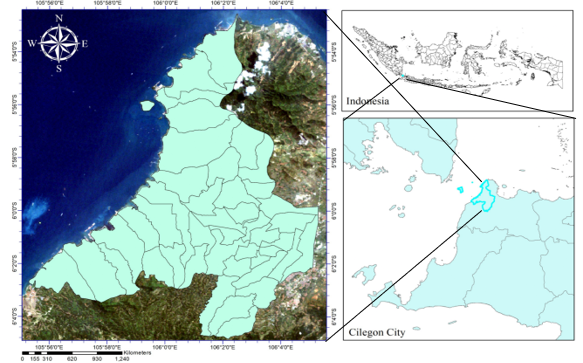
Agricultural land transition in rapidly urbanizing coastal regions poses significant challenges for sustainable land use planning and long-term food security. This study examines the driving forces behind agricultural land conversion in Cilegon City, Banten Province, Indonesia as one of Southeast Asia's most industrialized coastal cities by integrating Remote Sensing (RS), Geographic Information Systems (GIS), and the Analytical Hierarchy Process (AHP) with structured local knowledge elicitation. Land cover classification was performed using Random Forest machine learning applied to multi-temporal Landsat imagery (2011 and 2023), revealing substantial encroachment of non-agricultural land uses. Through pairwise comparison interviews with six domain experts, AHP weighting assigned the highest influence to rainfall (18%), soil quality (15%), and road accessibility (14%) as transition drivers. The resulting transitional suitability map, validated against observed land cover change, achieved an overall accuracy of 88.70% and a Kappa coefficient of 0.86, demonstrating the model's strong predictive capacity. The findings underscore that environmental, infrastructural, and socio-economic factors collectively govern land conversion dynamics. This study contributes a replicable, participatory spatial framework that bridges objective geospatial data with community-embedded knowledge, supporting more inclusive, evidence-based urban planning and agricultural land management in fast-growing coastal cities.
Keywords: analytical hierarchy process, coastal city, land use change, local knowledge, remote sensing.
Downloads
References
Anderson, J. R., Hardy, E. E., Roach, J. T., & Witmer, R. E. (1976). A land use and land cover classification system for use with remote sensor data (U.S. Geological Survey Professional Paper 964). Washington, D.C.: U.S. Government Printing Office. https://doi.org/10.3133/pp964
Carletta, J. (1996). Assessing agreement on classification tasks: the Kappa statistic. Computational Linguistics, 22(2), 249–254.
Congalton, R. G. (1991). A review of assessing the accuracy of classifications of remotely sensed data. Remote Sensing of Environment, 37(1), 35–46. https://doi.org/10.1016/0034-4257(91)90048-B
Breiman, L. (2001). Random forests. Machine learning, 45(1), 5–32.
Bren d’Amour, C., Reitsma, F., Baiocchi, G., Barthel, S., Güneralp, B., Erb, K. H., et al. (2017). Future urban land expansion and implications for global croplands. Proceedings of the National Academy of Sciences, 114(34), 8939–8944. https://doi.org/10.1073/pnas.1606036114
Doydee, P. (2005). Coastal land use change detection using remote sensing technique: a case study in Banten Bay, West Java island, Indonesia. Agriculture and Natural Resources, 39(1), 159–164.
Foody, G. M. (2002). Status of land cover classification accuracy assessment. Remote Sensing of Environment, 80(1), 185–201. https://doi.org/10.1016/S0034-4257(01)00295-4
Gandharum, L., Mulyani, M. E., Hartono, D. M., Karsidi, A., & Ahmad, M. (2021). Remote sensing versus the area sampling frame method in paddy rice acreage estimation in Indramayu regency, West Java province, Indonesia. International Journal of Remote Sensing, 42(5), 1738–1767. https://doi.org/10.1080/01431161.2020.1842541
Jensen, J. R., & Im, J. (2007). Remote sensing change detection in urban environments. Geospatial Technologies in Urban Environments: Policy, Practice, and Pixels, 7–31. https://doi.org/10.1007/978-3-540-69417-5_2
Landis, J. R., & Koch, G. G. (1977). The measurement of observer agreement for categorical data. Biometrics, 33(1), 159–174. https://doi.org/10.2307/2529310
Li, L., Huang, X., & Yang, H. (2023). Scenario-based urban growth simulation by incorporating ecological-agricultural-urban suitability into a future land use simulation model. Cities, 137, 104334. https://doi.org/10.1016/j.cities.2023.104334
Lobell, D. B., et al. (2015). Rainfall variability and agricultural land abandonment in semi-arid regions. Nature Climate Change, 5(3), 220–226.
Long, H., Tang, G., Li, X., & Heilig, G. K. (2007). Socio-economic driving forces of land-use change in Kunshan, the Yangtze river delta economic area of China. Journal of Environmental Management, 83(3), 351–364.
Moon, S. (2009). Justice, geography, and steel: technology and national identity in Indonesian industrialization. Osiris, 24(1), 253–277. https://doi.org/10.1086/605978
Ngongo, Y., DeRosari, B., Basuki, T., Njurumana, G. N., Nugraha, Y., Harianja, A. H., et al. (2023). Land cover change and food security in central Sumba: challenges and opportunities in the decentralization era in Indonesia. Land, 12(5), 1043. https://doi.org/10.3390/land12051043
Purnamasari, R. A. (2024). Land suitability evaluation for sugarcane cultivation based on agroecological zoning system in East Java, Indonesia. Buitenzorg: Journal of Tropical Science, 1(2), 42–50. https://doi.org/10.70158/buitenzorg.v1i2.12
Purnamasari, R. A., Noguchi, R., & Ahamed, T. (2019a). Land suitability assessments for yield prediction of cassava using geospatial fuzzy expert systems and remote sensing. Computers and Electronics in Agriculture, 166, 105018. https://doi.org/10.1016/j.compag.2019.105018
Purnamasari, R. A., Ahamed, T., & Noguchi, R. (2019b). Land suitability assessment for cassava production in Indonesia using GIS, remote sensing and multi-criteria analysis. Asia-Pacific Journal of Regional Science, 3, 1–32. https://doi.org/10.1007/s41685-018-0079-z
Purnamasari, R. A., Setiawan, M., Wardah, W., Oryzanti, P., Oktaviani, D., & Purwanto, Y. (2024). Remote sensing application and machine learning approach to estimate the availability of local food: a case study of urban area in Indonesia. In T. Ahamed (Ed.), Remote sensing application II New frontiers in regional science: Asian perspectives (pp. 405–427). Singapore: Springer. https://doi.org/10.1007/978-981-97-1188-8_15
Purnamasari, R. A., Setiawan, M., & Wardah, W. (2025). Land degradation detection in urban areas using spatial modelling and semi-automatic classification of satellite imagery data. Tropical Aquatic and Soil Pollution, 5(2), 110–124. https://doi.org/10.53623/tasp.v5i2.775
Purnamasari, R. A., Wardah, W., Ridwan, R., Setiawan, M., Sundari, S., Sadili, A., ... & Pulungan, N. A. H. J. (2026). Land evaluation of Tacca tuber distribution on the marginal coastal area using fuzzy and maximum entropy modelling. Cogent Food & Agriculture, 12(1), 2656489.
Saaty, T. L. (1980). The analytic hierarchy process: planning, priority setting, resource allocation. New York: McGraw-Hill International Book Company.
Seto, K. C., Fragkias, M., Güneralp, B., & Reilly, M. K. (2011). A meta-analysis of global urban land expansion. PLOS One, 6(8), e23777. https://doi.org/10.1371/journal.pone.0023777
Tassi, A., Massetti, A., & Gil, A. (2022). The spectralrao-monitoring Python package: a RAO's Qdiversity index-based application for land-cover/land-use change detection in multifunctional agricultural areas. Computers and Electronics in Agriculture, 196, 106861. https://doi.org/10.1016/j.compag.2022.106861
Tu, S., & Long, H. (2017). Rural restructuring in China: theory, approaches and research prospect. Journal of Geographical Sciences, 27(10), 1169–1184. https://doi.org/10.1007/s11442-017-1429-x
Yu, C., Hu, Z., Li, R., Xia, X., Zhao, Y., Fan, X., & Bai, Y. (2022). Segmentation and density statistics of mariculture cages from remote sensing images using mask R-CNN. Information Processing in Agriculture, 9(3), 417–430. https://doi.org/10.1016/j.inpa.2021.04.013
Downloads
Published
How to Cite
Issue
Section
License
Copyright (c) 2026 Buitenzorg: Journal of Tropical Science

This work is licensed under a Creative Commons Attribution-ShareAlike 4.0 International License.
The article is licensed under a Creative Commons Attribution-ShareAlike 4.0 International License (CC BY-SA), which allows both Authors and Readers to copy and distribute the material in any format or medium, as well as modify and create derivative works from it for any purpose, provided that appropriate credit is given (by citing the article or content), a link to the license is provided, and it is indicated if any changes were made. If the material is modified or used to create derivative works, the contributions must be distributed under the same license as the original.