Land suitability evaluation for sugarcane cultivation based on agroecological zoning system in East Java Indonesia
DOI:
https://doi.org/10.70158/buitenzorg.v1i2.12Abstract
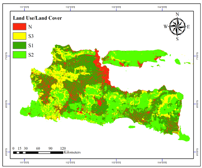
Agroecological zoning system is essential to accelerate the production of plantation crops such as sugarcane. This is a tool that helps to identify the most suitable areas for growing specific crops based on the physical and biological characteristics of the land. The ideal conditions for sugarcane growth can be achieved from optimal planting land conditions and adequate climate and fertilization. Land use planning is key to the sustainability of plantation crops in Indonesia. In this study, we used land suitability evaluation for sugarcane cultivation using an agroecological zoning system. Multisource of suitability criteria was used from the thematic map that included the land use/land cover map, slope map, rainfall map, and soil type map as physical and biological characteristics of the land. On the land suitability map for sugarcane cultivation, the results are in the form of land area that was adjusted to the Food and Agriculture Organization indicators regarding land suitability class. We found that 23.20% of the area (11,149.49 km2) was very suitable for sugarcane cultivation, 30.18% (14,499.67 km2) was moderately suitable, 36.05% (17,321.71 km2) was marginally suitable, and 10.55% (5,068.25 km2) was not suitable for sugarcane plantation. In this study, it was found that around 1,114,949 ha of land in East Java had the potential to become sugarcane plantations based on the agroecological zoning system. This research recommended that the integrated approach of Geographic Information Systems (GIS) with satellite remote sensing vegetation datasets utilization might help to develop the site-specific management of sugarcane plantations.
Keywords: agroecological zone, land suitability, mapping, remote sensing, sugarcane.
Downloads
References
Al-Taani, A., Al-Husban, Y., & Farhan, I. (2021). Land suitability evaluation for agricultural use using GIS and remote sensing techniques: The case study of Ma’an governorate, Jordan. The Egyptian Journal of Remote Sensing and Space Science, 24(1), 109–117. https://doi.org/10.1016/j.ejrs.2020.01.001
BPS-Statistics Indonesia. (2022). Indonesia sugarcane statistics 2021, catalogue: 5504004. Badan Pusat Statistik, Jakarta. https://www.bps.go.id/id/ publication/2022/11/30/6392bf8e4265949485d85e72/statistik-tebu-indonesia-2021.html
Fageria, N., K., & Moreira, A. (2011). The role of mineral nutrition on root growth of crop plants. In: Sparks, D. L. (ed.) Advances in Agronomy, vol. 110. Burlington: Academic Press. https://doi.org/10.1016/B978-0-12-385531-2.00004-9
FAO (2007). A framework for land evaluation. Food and Agriculture Organization, Rome.
Feizizadeh, B., & Blaschke, T. (2014). An uncertainty and sensitivity analysis approach for GIS-based multi-criteria erosion susceptibility mapping. International Journal of Geographical Information Science, 28(3), 610–638. https://doi.org/ 10.1080/13658816.2013.869821
Fischer, G., van Velthuizen, H. T., & Nachtergaele, F. O. (2000). Global agro-ecological zones assessment: methodology and results. https://pure.iiasa.ac.at/id/eprint/6182
Flynn, K. C. (2019). Site suitability analysis for tef (Eragrostis tef) within the contiguous United States. Computers and Electronics in Agriculture, 159, 119–128. https://doi.org/10.1016/j.compag.2019.02.016
Gunarathna, M. H. J. P., Sakai, K., Nakandakari, T., Momii, K., Onodera, T., Kaneshiro, H., Uehara, H., & Wakasugi, K. (2018). Optimized subsurface irrigation system: The future of sugarcane irrigation. Water, 10(3), 314. https://doi.org/10.3390/w10030314
Hegazy, I. R., & Kaloop, M. R. (2015). Monitoring urban growth and land use change detection with GIS and remote sensing techniques in Daqahlia governorate Egypt. International Journal of Sustainable Built Environment, 4(1), 117–124. https://doi.org/10.1016/j.ijsbe.2015.02.005
Jamil, M., Ahmed, R. & Sajjad, H. (2018). Land suitability assessment for sugarcane cultivation in Bijnor district, India using geographic information system and fuzzy analytical hierarchy process. GeoJournal, 83, 595–611. https://doi.org/10.1007/s10708-017-9788-5
Li, H., & Chen, Y. (2020). The spatial sensitivity analysis of land irrigation suitability evaluation based on groundwater data of Xinjiang inland river basin. Computers and Electronics in Agriculture, 177, 105680. https://doi.org/10.1016/ j.compag.2020.105680
Ligmann-Zielinska, A., & Jankowski, P. (2014). Spatially-explicit integrated uncertainty and sensitivity analysis of criteria weights in multicriteria land suitability evaluation. Environmental Modelling & Software, 57, 235–247. https://doi.org/10.1016/j.envsoft.2014.03.007
Machado, P. G., Rampazo, N. A. M., Picoli, M. C. A., Miranda, C. G., Duft, D. G., & de Jesus, K. R. E. (2017). Analysis of socioeconomic and environmental sensitivity of sugarcane cultivation using a Geographic Information System. Land Use Policy, 69, 64–74. https://doi.org/10.1016/j.landusepol.2017.08.039
Malczewski, J. (1999). GIS and Multicriteria Decision Analysis. New York. Wiley.
Marwoto, & Candra, D. S. (2007) Pembuatan sistem informasi geografis kesesuaian lahan tanaman tebu berbasis web di kabupaten Merauke. Jurnal Penginderaan Jauh dan Pengolahan Data Citra Digital, 4(1), 60–71. https://jurnal.lapan.go.id/index.php/jurnal_inderaja/article/view/510/439
Ministry Agriculture of Indonesia (2017). Peta jalan (roadmap) tebu menuju Indonesia sebagai lumbung pangan dunia 2045. Kementerian Pertanian, Jakarta, Indonesia.
Nabati, J., Nezami, A., Neamatollahi, E., & Akbari, M. (2020). GIS-based agro-ecological zoning for crop suitability using fuzzy inference system in semi-arid regions. Ecological Indicators, 117, 106646. https://doi.org/10.1016/j.ecolind.2020.106646
Nguyen, H., Nguyen, T., Hoang, N., Bui, D., Vu, H., & Van, T. (2020). The application of LSE software: A new approach for land suitability evaluation in agriculture. Computers and Electronics in Agriculture, 173, 105440. https://doi.org/10.1016/ j.compag.2020.105440
Prabhjyot-Kaur, Kaur, S., Dhir, A. Kaur, H. & Vashisht B. B. (2024). Agro-Eco-Resource Zonation (AERZ) for sustainable agriculture using GIS and AHP techniques in Indian Punjab. Theor Appl Climatol, 155, 8047–8066. https://doi.org/10.1007/ s00704-024-05104-4
Purnamasari, R. A., Ahamed, T., & Noguchi, R. (2019). Land suitability assessment for cassava production in Indonesia using GIS, remote sensing and multi-criteria analysis. Asia-Pacific Journal of Regional Science, 3(1), 1–32. https://doi.org/10.1007/ s41685-018-0079-z
Ramamurthy, V., Reddy, G. O., & Kumar, N. (2020). Assessment of land suitability for maize (Zea mays L.) in semi-arid ecosystem of southern India using integrated AHP and GIS approach. Computers and Electronics in Agriculture, 179, 105806. https://doi.org/10.1016/ j.compag.2020.105806
Reuters (2018). Indonesia raw sugar consumption for food, beverages seen edging up in. Retrieved from https://www.reuters.com/article/indonesia-sugar/indonesia-raw-sugar-consumption-for food-beverages-seen-edging-up-in-2018-idUSJ9N1I400
Saaty, T. L. (1980). The analytic hierarchy process. New York: McGraw-Hill.
Silva-Olaya, A.M., Cerri, C.E.P., Williams, S. Cerri C. C., Davies C. A. & Paustian K. (2017). Modelling SOC response to land use change and management practices in sugarcane cultivation in South-Central Brazil. Plant Soil, 410, 483–498. https://doi.org/10.1007/s11104-016-3030-y
Sulaiman, A. A., Sulaeman, Y., Mustikasari, N., Nursyamsi, D., & Syakir, A. M. (2019). Increasing sugar production in Indonesia through land suitability analysis and sugar mill restructuring. Land, 8(4), 61. https://doi.org/10.3390/land8040061
Sys, C., Ranst, E. & Debavey, J. (1991). Land evaluation part I: Principles in land evaluation and crop production calculations. Brussels, Belgium: General Administration for Development Cooperation.
Worqlul, A. W., Dile, Y. T., Jeong, J., Adimassu, Z., Lefore, N., Gerik, T., Srinivasan, R., & Clarke, N. (2019). Effect of climate change on land suitability for surface irrigation and irrigation potential of the shallow groundwater in Ghana. Computers and Electronics in Agriculture, 157, 110–125. https://doi.org/10.1016/ j.compag.2018.12.040

Downloads
Published
How to Cite
Issue
Section
License
Copyright (c) 2024 Buitenzorg: Journal of Tropical Science

This work is licensed under a Creative Commons Attribution-ShareAlike 4.0 International License.
The article is licensed under a Creative Commons Attribution-ShareAlike 4.0 International License (CC BY-SA), which allows both Authors and Readers to copy and distribute the material in any format or medium, as well as modify and create derivative works from it for any purpose, provided that appropriate credit is given (by citing the article or content), a link to the license is provided, and it is indicated if any changes were made. If the material is modified or used to create derivative works, the contributions must be distributed under the same license as the original.


